Aerial photo of Chatsworth, Calif., circa 1920s
I found an old bird's-eye view of Chatsworth, Calif., at the library, and while it's low-res by today's Bing and Google Earth standards, it's also an important shot from a film history standpoint. The photo provides a number of insights into the area surrounding the Iverson Movie Ranch when it was first getting up to speed as a filming location back in the silent movie era. I'll point out a few of the highlights in the shots that follow, and I recommend that you click on these photos to see larger versions of them.
The above notated version of the shot shows where the Iverson Movie Ranch, divided into its upper and lower halves, fits into the landscape. The photo is not clear enough to provide a meaningful look at the Iverson Ranch itself, but it helps put the nearby hills, roads and other features in perspective. The photo is not dated, but appears to be from sometime in the 1920s.

This version of the old photo spotlights Oat Mountain, which may be the most frequently seen background feature in productions filmed on the Iverson Movie Ranch — especially the Upper Iverson. Also noted here are Stoney Point — a Chatsworth landmark next to Topanga Canyon Boulevard that today is a popular rock-climbing destination — and a portion of the Brandeis Ranch that I call Brandeis Plain, which is also widely seen in the background in productions shot on the Upper Iverson. Brandeis, located immediately to the west of the Upper Iverson, was a filming location itself for a short period of time, mainly in the late 1930s and the 1940s.

One of the most exciting discoveries for me in the early photo is a road that is now known as Johnson Motorway or Johnson Mountain Way. These days the road, besides serving as a fire break, is part of a hiking loop that includes the Rocky Peak area to the west. But the discovery that it already existed as a relatively well-defined road as far back as the 1920s means it would have been used as a route into and out of the northwestern corner of the San Fernando Valley. This route is not nearly as well-known as Santa Susana Pass Road, which connected — and still connects — the San Fernando and Simi valleys, nor is it as well-documented as the old stagecoach road, which is not seen in this shot but entered the San Fernando Valley below Santa Susana Pass Road.
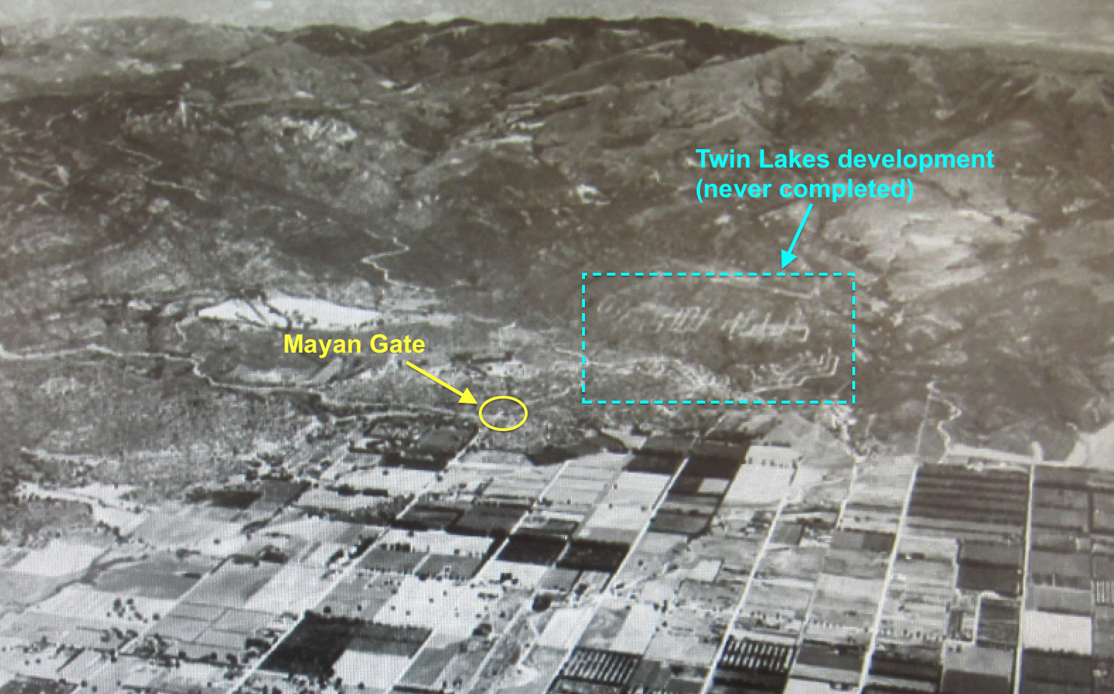
The old road winding its way up the hill toward the northwest connected up in those days with Mayan Drive, part of a planned development known as Twin Lakes, which never took off. Today a small residential area at the northern end of Topanga bears the name Twin Lakes, and Mayan Drive runs through the neighborhood, connecting the top of Topanga with the top of Canoga. This neighborhood was only a small part of the grand scheme that was the proposed Twin Lakes development, and today the hills remain marked with some of the proposed residential streets that were carved out but never had homes built on them. This shot also points out the location of the old Mayan Gate that marked the entrance to Twin Lakes. The gate stood for a few decades at the southeast corner of the Iverson Movie Ranch.
The Mayan Gate, marking the entrance to the Twin Lakes development
The above view of the gate looks south, and would be the view visitors would get when leaving the Twin Lakes area. I know of one occasion when the Mayan Gate appeared in an old movie — the James Cagney feature "White Heat," which I discussed in
this earlier blog entry.
The Twin Lakes development area as it appears in a modern aerial shot
Here's a modern aerial photo showing the area of the proposed Twin Lakes development. The neighborhood now known as Twin Lakes, which appears at the bottom of the photo, is filled with residential housing that I do not believe had anything to do with the original development, even though the original Mayan Drive still winds through the neighborhood. Meanwhile, many of the roads that were carved out in the 1920s were never used for housing, and remain etched into the hills above the northwest San Fernando Valley — as can be seen toward the top of the photo.
One feature that can be easily matched up between the circa 1920s bird's-eye photo and productions shot at Iverson is a short section of road set against the hills to the north of the Upper Iverson. I have been calling this section "Road Up the Hill" in my research, but thanks to the old bird's-eye shot, I now know that it was part of that road that extended far to the northwest — the same road now known as Johnson Motorway.
"Go West, Young Lady" (1941) — Road Up the Hill
Here's an example of a movie appearance by Road Up the Hill, in Columbia's musical-comedy Western "Go West, Young Lady," which starred Glenn Ford, Penny Singleton and Ann Miller. This shot is taken on the Upper Iverson, and Road Up the Hill can be seen in the top right corner. I'll point out some of the key features in the next photo.
Here's the same shot with a number of features highlighted. The Line of Trees divided the Upper Iverson Movie Ranch from the Brandeis Plain and the Brandeis Movie Ranch. Road Up the Hill can be seen in the backgrounds of countless chase sequences filmed on both the Upper Iverson and the Brandeis Ranch. In this shot, a stagecoach can be seen speeding across the Upper Iverson near the center of the frame.
"Johnny Concho" (1956)
Here's another look at Road Up the Hill, from the Frank Sinatra Western "Johnny Concho." Road Up the Hill appears near the top left corner, and this shot also features Bear Tree — a photogenic Upper Iverson oak tree that still survives today.
This is the same "Johnny Concho" shot, pointing out Road Up the Hill and Bear Tree. Bear Tree is a recent discovery that I discussed in detail in
this earlier blog post.
Frank Sinatra and Phyllis Kirk in "Johnny Concho"
Postingan terkait:


Belum ada tanggapan untuk "Bird's-eye view of Chatsworth, Calif., in the 1920s offers a glimpse at movie history"
Posting Komentar